
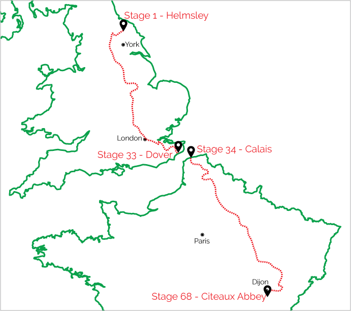
 St. Bernard’s Way is a 1573.4 km / 977.7 mile long distance walking route from Rievaulx Abbey, North Yorkshire, England to Citeaux Abbey, south of Dijon in France. It has been created in recognition of monastic travels that were undertaken in the 12th to 14th centuries, and of St. Bernard of Clairvaux who was instrumental in the development and expansion of the Cistercian Order.
St. Bernard’s Way follows the popular pilgrim route ‘Via Francigena’ between Canterbury and Beaujeu, France, where the St. Bernard’s Way then continues on its own route to Citeaux Abbey. This is the route that the Abbot of Rievaulx Abbey and his companions will have taken each year in order to attend their General Chapter meeting at Citeaux Abbey on Holy Day, 11 September.
Learn More before you walk:
This long distance walk links with several other popular National Trails and established long distance paths including the Cleveland Way, North Downs Way, Ridgeway and Thames Path National Trails, the Barnsley Boundary Walk, Chiltern Way, Darent Valley Path, Dearne Way, Ebor Way, Harrogate Ringway, Leeds Country Way, Mowbray Way, Nene Way, Nidderdale Way, Pilgrim's Way, Shining Lights of the North Way, Swale Way, and the Trans Pennine Way plus many more !
St Bernard’s Way has 33 stages in the UK, and 35 in France. We have started and ended each stage at locations where accommodation is available. Stage walk times are based on Naismith's Rule.
Click on a stage name to get details and see map information.
| Stage Number / Name | Distance ( km ) | Distance ( miles ) | Time ( hours ) |
|
13.4 |
8.6 |
3 - 3.5 |
|
|
18.5 |
11.6 |
4 - 4.5 |
|
|
23.3 |
14.5 |
5 - 5.5 |
|
|
18.3 |
11.3 |
4 - 4.5 |
|
|
33.1 |
20.7 |
8 - 8.5 |
|
|
13.9 |
8.6 |
3.5 - 4 |
|
|
36.5 |
22.6 |
9 - 9.5 |
|
|
24.4 |
15.1 |
5.5 - 6 |
|
|
20.3 |
12.6 |
4.5 - 5 |
|
|
25.6 |
15.9 |
6 - 6.5 |
|
|
31.5 |
19.5 |
7.5 - 8 |
|
|
24.9 |
15.4 |
6 - 6.5 |
|
|
32.5 |
20.3 |
8 - 8.5 |
|
|
30.0 |
18.6 |
7.5 - 8 |
|
|
29.3 |
18.2 |
7 - 7.5 |
|
|
15.3 |
9.5 |
3.5 - 4 |
|
|
28.5 |
17.1 |
6 - 6.5 |
|
|
25.9 |
16.0 |
5.5 - 6 |
|
|
17.6 |
11.0 |
4 - 4.5 |
|
|
17.6 |
11.0 |
4 - 4.5 |
|
|
18.7 |
11.7 |
4.5 - 5 |
|
|
13.5 |
8.4 |
3 - 3.5 |
|
|
24.5 |
15.2 |
5 - 5.5 |
|
|
18.8 |
11.6 |
4.5 - 5 |
|
|
29.6 |
18.3 |
7 - 7.5 |
|
|
15.5 |
9.6 |
3 - 3.5 |
|
|
30.6 |
19.0 |
7.5 - 8 |
|
|
12.0 |
7.4 |
3 - 3.5 |
|
|
19.6 |
12.1 |
4.5 - 5 |
|
|
14.7 |
9.2 |
3.5 - 4 |
|
|
24.9 |
15.5 |
6 - 6.5 |
|
|
24.1 |
14.9 |
5.5 - 6 |
|
|
31.2 |
19.3 |
7.5 - 8 |
|
|
31.6 |
19.6 |
7.5 - 8 |
Click on a stage name to get details and see map information.
| Stage Number / Name | Distance ( km ) | Distance ( miles ) | Time ( hours ) |
|
10.8 |
6.7 |
2.5 - 3 |
|
|
17.2 |
10.6 |
4 - 4.5 |
|
|
16.6 |
10.3 |
3 - 3.5 |
|
|
18.7 |
11.6 |
4 - 4.5 |
|
|
12.4 |
7.7 |
3 |
|
|
18.1 |
11.2 |
4.5 - 5 |
|
|
25.2 |
15.6 |
7 - 7.5 |
|
|
26.5 |
16.4 |
6.5 - 7 |
|
|
40.2 |
24.9 |
9.5 - 10 |
|
|
29.3 |
18.2 |
7.5 - 8 |
|
|
27.4 |
17.0 |
7 - 7.5 |
|
|
19.8 |
12.0 |
4.5 - 5 |
|
|
29.9 |
19.0 |
7.5 - 8 |
|
|
33.7 |
33.7 |
8 - 8.5 |
|
|
26.7 |
16.5 |
6.5 - 7 |
|
|
19.3 |
11.9 |
4.5 - 5 |
|
|
15.9 |
9.8 |
4 - 4.5 |
|
|
38.7 |
24.0 |
9.5 - 10 |
|
|
18.1 |
11.2 |
4.5 - 5 |
|
|
27.9 |
17.5 |
6.5 - 7 |
|
|
18.9 |
11.7 |
4.5 - 5 |
|
|
31.0 |
19.2 |
7.5 - 8 |
|
|
20.9 |
12.9 |
5 - 5.5 |
|
|
10.5 |
6.0 |
2.5 - 3 |
|
|
15.6 |
9.3 |
3 - 3.5 |
|
|
35.9 |
22.3 |
8.5 - 9 |
|
|
25.5 |
16.0 |
6.5 - 7 |
|
|
32.8 |
20.3 |
7.5 - 8 |
|
| Stage 62: Coublanc to Dampierre-sur-Salon | 32.7 | 20.3 | 7 - 7.5 |
|
35.0 |
21.7 |
8.5 - 9 |
|
|
31.9 |
19.8 |
8 - 8.5 |
|
|
16.9 |
10.5 |
4 - 4.5 |
|
|
12.0 |
7.5 |
3 - 3.5 |
|
|
27.3 |
17.0 |
6.5 - 7 |
