
|
Distance |
30.9km / 19.2 miles |
|
|
Explorer maps |
York - OL290, Malton - OL300 |
|
|
Time |
7.5 - 8 hours average time based on Naismith’s rule |
|
| Total ascent | 317m | |
|
Total descent
|
246m
|
|
|
Waypoint coordinates |
|
|
| Download PDF |
|
|
|
Overview |
This is a pleasant route that leaves the city of York, past The Minster and through the Roman gate of Monkbar to reach the river Foss. Follow the Foss Walk on sections of the river bank, through fields and along quite country lanes to Crayke.
Along the way pass through the model Quaker village of New Earswick built for the employees of Joseph Rowntrees chocolate factory ( now Nestle ). Continue through the medieval villages of Haxby and Farlington, home to St Leonard's Anglican Church -12th century. In Marton pass St. Mary’s church, 12th century built on a Saxon site and past Marton Priory which was a double house of Augustinian canons and Benedictine nuns founded in 1154, parts of which are now Abbey Farm.
In 1316 the whole of this stage would have been the Royal Galtres Forest which comprised of 60 villages in 100,000 acres, predominantly silver birch trees. |
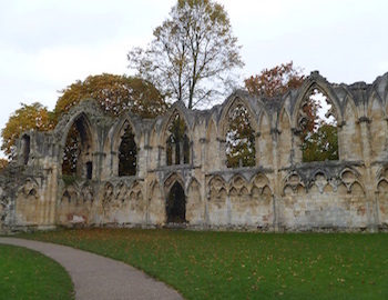
1 - From St Mary's Abbey York pass the Yorkshire Museum on the left to leave the Museum Gardens. At the road (MuseumStreet) turn left and head to the Minster and bear right to pass it on the left and St Michael le Belfrey church on the right.
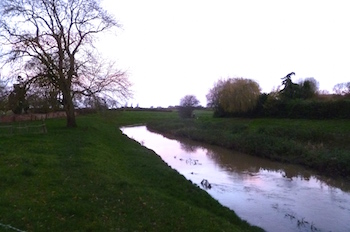
2 - Continue along Deangate pass the Cross Keys pub on the right and straight ahead into Goodramgate (not right). Pass through Monkgate Bar and the city walls and straight ahead at the crossroad to the roundabout. Go straight ahead, direction Scarborough A1036 and after passing over the river turn left into the garden to walk along the river path with the River Foss on the left. This section can be very muddy/boggy.
3 - After passing under an old disused railway reach a playing field. Turn left and up the steps to leave the field and reach a road, Fossway. Turn left to the crossroad and turn right (Huntington Road) and immediately left before the bridge to go down steps to reach the left bank of the River Foss.
4 - Continue along the river bank and at the footbridge over the river continue ahead along the leftside to reach Haxby road (don’t cross the bridge). Turn right and then bear right to pass the White House on the left and continue along the river through New Earswick village. Where the path turns right bear right and ahead keeping by the
river to reach a metal gate.
5 - Continue through the gate and along the river to reach a road (this section can be very muddy too). Turn left towards St Andrews church, Huntington and then right through the car park to return to the river bank. continue ahead to pass underneath a road. At the footbridge cross over and turn left to walk on the right side of the river and then left recross it to reach a concrete road. Turn right to the main road and then right to leave the village of Haxby along Towthorpe Road.
6 - Pass underneath the electricity cables and after the road bends right with the railway line on the left,turn right after thesecond telegraph pole, before crossing over the stream on the road. Cross over the stream using the wooden bridge and continue ahead to cross the field towards the bridge and the river bank.
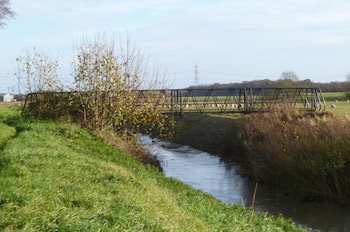
7 - At the bridge go up the steps and across the road to rejoin the river bank with it on the right. Eventually pass some modern houses on the left to reach a road. Cross over and continue along the river bank, signed Centenary Way.
8 - At the metal bridge that crosses the river Foss turn left into the trees to reach a field. Turn right along the field boundary towards an electricity pylon
ahead. Pass a farm on the right (Ings Lane) and and after passing
underneath electricity wires reach a crossroad. Turn left,Lilling Low Lane to the main road. Turn left and after passing the cricket pitch on the right, pass over a stream and then turn immediately right to walk along the bank with the stream on the right to reach a lane.
9 - Turn right past Foss House and then at a T-junction turn left toward a house in the distance on the left hand side of the track. Pass Cornborough Farm and then turn right into the field and keep ahead to a wooden bridge (ignore the footpath on the right). Cross a stile in the far right hand corner
of the field and then across two paddocks to reach a farm yard. Turn right to pass an agricultural building on the left.
10 - At the end of the field before the gate turn left to reach a field. Cross
the field diagonally right across two stiles and down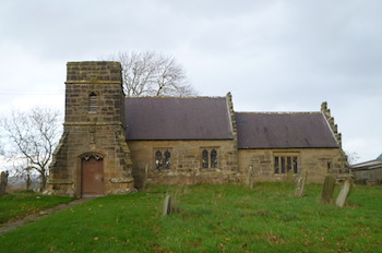 to Farlington Beck in the garden of a house. Follow the beck to the bridge and cross over it and turn right. Halfway along the field turn right to recross Farlington Beck and turn left to reach the village of Farlington.
11 - Turn left and then right (Foss Walk) to pass through black metal gates by a house and into the back garden and straight into the field ahead. Continue along the right side of the field to reach a concrete track. Turn right and immediately left to reach a path T-junction and turn right to the road.
12 - Turn left past the 12c St Mary’s Church and through the village of Marton. After passing Marton Grange on the right, where the road bends left, turn right onto Harryfield lane. Keep left and ahead where the lane
goes right to a farm and then straight ahead at the  path crossroads to pass Marton Abbey Farm on the right to reach a road.
13 - Turn right and then left, signed Foss Walk/Crayke 1 3/4 miles. Pass the farm on the left to Mosswood House and follow the footpath diversion right through the gate and left to join Mosswood lane. Turn right opposite Mosswood farm through two fields and at Bransby Lane reach the village of Crayke.
