
|
Distance |
32.3km / 20 miles | |
|
Explorer maps |
The Cheviot Hills OL16 | |
|
Time |
8.5 - 9 hours average time based on Naismith’s rule |
|
| Total ascent |
597m
|
|
| Total descent |
753m
|
|
|
Waypoint coordinates |
|
|
| Download PDF |
|
|
|
Overview |
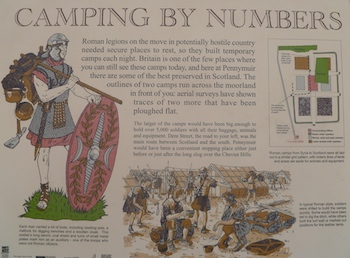
This is an isolated and initially strenuous walk over moorland following the Pennine Way before arriving at the Roman camp of Chew Green. There is nothing much to see except from large mounds. From the camp the route continues along the Roman road of Dere Street, before reaching and following the Borders Abbey Way to Jedburgh Abbey. There are no shops in Byrness so ensure you have suitable supplies from the day before and water. |
 1 - From Byrness retrace the path from the previous stage to the church of St Francis to pick up the Pennine Way. Turn left on the A68 and just after the road sign on the right, cross over the road to join the Pennine Way. After passing a building turn right to ascend the hill through the forest and across three tracks.
2 - Leave the forest and continue ahead to climb up to Byrness Hill. This is very exposed and can be very windy, take care. At the top turn left and continue on the Pennine Way across Houx Hill, Ravens Knowe and Ogre Hill. The path can be very boggy and slippery. At the end of the forest on the left cross into Scotland, Passport not required, and keep right and then right signed Chew Green to a path T-junction.
3 - Turn left along the grass track and then right across Chew Sike stream onto Dere Street before reaching the end of the camp site on the left. The path is not clear but it bears left up to a gate. Pass through it, now with a fence on the left, to reach a gateway into a signed section of Dere street. Continue along that to a fence boundary, cross over and turn left up to Blackhall Hill.
 4 - Descend the hill, very steep, to pick up a wide grass track that eventually bears right and then bear left with a stone wall on the right towards a stone tower. Just before it turn left onto Dere Street (the right of the two tracks) and a stone wall on the right to the road junction. Cross over and continue ahead over the bridge to the T-junction.
5 - Cross over and continue ahead passing a building on the left, the Roman road is quite damaged along this section due to farm vehicles and horse traffic. At the road turn left to a T-junction, cross over and continue along Dere Street and straight across three more roads. After the third road at the end of the trees on the right, turn left onto the Borders Abbey way heading towards a mast ahead. At the road bear left and down the hill to the main A68 road on the edge of Jedburgh town.
6 - Cross over the road and ahead following the river path and then bear right across the stone bridge and along Bridge Street to the T-junction. Turn right along High Street and then left after the cross road and right through the archway and left to the Abbey and the end of the stage.
