
|
Distance |
23.7km / 14.7 miles | |
|
Explorer maps |
Kielder Water & Forest OL42, The Cheviot Hills OL16 | |
|
Time |
6.5 - 7 hours average time based on Naismith’s rule |
|
| Total ascent |
409m
|
|
| Total descent |
307m
|
|
|
Waypoint coordinates |
|
|
| Download PDF |
|
|
|
Overview |
This is an isolated and sometimes strenuous walk over moorland that follows the Pennine Way to Byrness (pronounced Burness). There is one particularly boggy section before reaching the forest track, take care crossing it. This stage has few options to break off if the weather turns bad, you may want to be aware of these points just in case. Ensure you have a map of the area and familiar with using a compass / GPS in poor visibility and can navigate across the moors on poorly marked paths. There are no shops after leaving Bellingham so ensure you have suitable supplies and water. |
 1 - From the square turn right past the garage, direction Woodbury to leave the village. Ignore the right to Redesmouth but pass the Carriages tea room at the old railway station. Pass the caravan park on the left and where the road bends right, continue straight ahead - marked Pennine Way. Pass through the farmyard and then diagonally right across the field to pass the footpath marker post and onto the moor. Ignore the alternative Pennine Way path but continue ahead towards the wood in the distance.
2 - At the tarmac track turn right and then left just after the building on the left to a gate. Pass through it and continue ahead on the Bridleway to reach the road. (BREAK OFF POINT) Cross over and bear right passing a large mound on the right. Continue on the faint path across the moor passing the occasional Pennine Way marker posts along the route. Pass Lough Shaw on the right and a steady ascent to pass a Boundary Stone and a slight descent to Whitley Pike.
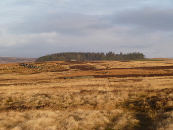
3 - At Whitley Pike turn right across the stone path to the road. Cross over and continue ahead passing Padon Hill and the monument on the right. Descend down towards the wood and then ascend up to Brownrigg Head keeping the boundary wall and fence on the right. At the corner naturally follow it left across a very boggy section keeping the wood on the left to reach the forest track.
 NB - To avoid the very boggy section which is dreadful to cross, at the road turn left and keep right past Keepers cottage. Continue ahead on the forest track
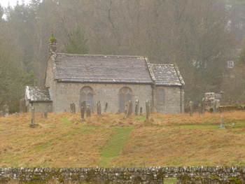
4 - Turn right at the track and continue on the wide forest track ignoring any left or right turns. Pass a disused quarry on the right and a farm on the left after leaving the forest. After crossing the second bridge turn left, Pennine Way keeping the River Rede on the left reach a track just before the campsite. Turn left across the river and just before the house ahead turn right to cross the river once more. Continue ahead to pass St Francis church and then turn left to reach Byrness village and the end of the stage.
