
|
Distance |
20.5km / 12.7 miles |
|
|
Explorer maps |
York - OL290 |
|
|
Time |
5 - 5.5 hours average time based on Naismith’s rule |
|
| Total ascent | 60m | |
|
Total descent
|
86m
|
|
|
Waypoint coordinates |
|
|
|
Download PDF |
|
|
|
Overview |
This is a very pleasant and easy walk from Whixley to pass through the medieval villages of Green Hammerton and Nether Poppleton. The route travels through fields, tracks, quite country lanes and along parts of what was the Roman road of Dere Street, now lost under tarmac and modern main roads.
In York follow the River Ouse towpath before crossing the river at Lendal Bridge to reach the 12th century Benedictine Abbey in the Museum Gardens. |
1 - In Whixley continue along High Street past the pub on the left. Where the road runs left continue ahead and bear diagonally left through fields to reach the road. Turn right on the B6265 road and then left into the village of Green Hammerton along Boroughbridge road. After passing the pub on the left, turn left and continue on New Lane which becomes Red Lane when it turns right.
2 - Pass a wooden gate marked no camping / no bonfires and take the next left footpath, hedge on the right. At the end cross into a field and bear slightly diagonally right to cross a small wooden bridge. After crossing into the field, keep diagonally right over three further fields to reach a stile in a hedge and Pool Lane. Cross straight over the Lane and after the first large section of hedge on the right bear diagonally right across the first field and then straight ahead and around a fenced area on the right in the next field to reach the A59 Harrogate road.
3 - Take care to cross over the road and continue ahead on the old road over the river to meet the A59 again. Turn right and keeping off the road, walk with the traffic coming towards you, again take care. At the second farm building on the left, turn left into and out of the farmyard. Continue to reach a small farm building on the left and turn right over the stile into a field and turn immediately left to cross a bridge over the Great Gutter stream.
4 - Continue ahead up the incline, across Low Road to reach a metal gate at a field corner, the River Nidd is on the left. Continue through the gate and four fields, keeping to the left side to reach a gate at a green lane. Continue along the green lane and where it bends right take the footpath left along the ridge of the field with farm buildings on the right. Cross into a house garden (This is a footpath), past the vegetable plot and around the house and left at the lane to a junction with Church Lane.
5 - Continue ahead and along East Lane at the end of the village. Pass a large electricity pylon on the left and through two large fields to a narrow muddy footpath. Bear left following a stream on the left. After passing into a second field follow the field boundary to eventually have the hedge on the left to then pass through agricultural buildings to reach Red House Lane.
6 - Continue across the lane and along the small tarmac road past Thickpenny Farm on the left to reach a gate into a field. Cross the field diagonally right to Scally Moor Farm. Turn left into the farm garden and immediately right to pass in front of the house by the fence boundary and across the field to Woodhouse Farm. At Lords Lane turn right and then left into the fields and around New Farm to Main Street on the outskirts of Upper Poppleton.
7 - At the road turn left and after passing the pub on the right keep right and continue along Millfield Lane passing under the main road and keeping right to cross over the railway crossing. Pass through a small industrial area and where the lane bends right it becomes Low Poppleton Lane. At the T-junction turn left onto Boroughbridge Road, formerly the Roman road of Dere Street.
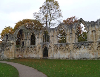
8 - Pass a fire station on the left, and after the shops bear left onto the
cycle / footpath and down Water Lane to the trafficlights. Turn right onto Salisbury Terrace and straight ahead into Jubilee Terrace to reach the cycle / footpath alongside the River Ouse on the left. Continue alongside the river and after passing the York City Rowing club on the right, go under a stone arch and turn immediately right up the steps, left and left again to cross the river. Turn left through the black metal gates into the Museum Gardens and keep right on the path past the York Museum to reach St Mary’s Abbey and the end of the stage.
