
|
Distance |
18.8 km / 11.6 miles |
|
|
Explorer maps |
Middlesbrough & Hartlepool - 306, Bishop Auckland - 305 |
|
|
Time |
4.5 - 5 hours average time based on Naismith’s rule |
|
| Total ascent |
155m
|
|
| Total descent |
56m
|
|
|
Waypoint coordinates |
|
|
| Download PDF |
|
|
|
Overview |
This is an easy stage, after a brief journey along the river the route follows and old disused railway line through and out of Stockton-On-Tees along the Route 1 cycleway and the Castle Eden Walkway. Pass through Thorpe Thewell and once more along fields and pleasant countryside to arrive at the Medieval town of Sedgefield and the end of the stage. |
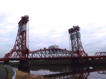 1. From the station turn left past the police station on the right up to the traffic lights. Turn right (railway line on the left) down to the roundabout and turn left and continue on Riverside Park Road. Keep left at the next roundabout and then left to pass over the railway line and then turn right to cross the Transporter bridge.
2. After crossing the river turn left down the steps to the riverside path and continue ahead with the river on the left. At the end of the nature reserve on the right, reach a footpath signed junction. Turn right to walk through the nature reserve and through the gate in the left corner, passing the supermarket on the right to reach the road junction. (A good opportunity to buy lunch)
3. Cross over using the pedestrian crossing, turn right and then left through the industrial estate on Holme House Road. At the roundabout turn left through the metal gate along a wide concrete track (former airport runway). Before reaching the end bear left signed Cycle route 1 to the end of the field. Bear right towards the housing estate and then keep left, signed Hardwick 3.
 4. Continue along the old railway line and at the end of a line of houses on the right, bear right (railway line on the left) to continue on Cycle route 1 to the road junction. Cross over the road and turn left under the railway line and then turn right. Cross over the field, straight across Rochester Road and along Romsey Road to the T- junction.
5. Turn left on Ragpath Lane, signed Castle Eden Walkway and then turn right and left onto Rothwell Crescent. After passing the school grounds on the left, the road naturally turns right. The path turns left between two houses to reach the main road A177 (Durham Road) and a pedestrian crossing. Cross over the road and turn right, continuing on the cycle route 1.
6. At the metal barrier on the right, turn left on Ketton Road towards the large chimney ahead, passing house No 92 on the right. The path continues past the hospital on the right to reach Hamsterley road. Continue ahead on the cycle route passing metal railings on the right and Nightingdale Drive.
7. Pass in between the metal railings bearing right on the cycle route and then keep left around the large pond on the left. Pass house No 55 on the right and at the end of Cowpen Crescent turn right and then left on Crawcrook walk passing house No 2 on the right. At the end cross the grass to reach the old railway line.
8. Turn right and continue ahead on the old railway line to the road. Cross over Harrowgate Lane and continue on the railway line across the metal bridge over the current railway line to Durham road. Turn left to Thorpe Thewell to the T-junction passing the end of the Hamilton Russell pub on the left.
9. Cross over Wynyard Road and past the information boards about the village history on the right. Just before reaching the main road turn left on the Bridleway (Hellhole Lane), signed Stillington 1.4 miles. At the end of the track continue between the fields and then ahead with a large hedge on the left.
10. After two fields, bear right with the stream on the left (Maudlin Gutter). At the road turn left and then right to cross the field. At the end turn right through the wood to reach a stile and fence. Turn right towards the large farm building, passing it on the right. Cross several fields and then across a bridge to reach a farm yard. (The bridge was closed 4/16, if thats the case head out of the field with the stream on the left. Turn left on the lane to pick up the footpath on the right before the farm)
11. Turn right and then left and after passing through a large field, keeping the tree in the middle of the field on the right to reach a footbridge. Cross over and continue through grass fields with the wood on the left. In the left corner, cross two stiles and then keep ahead towards the church spire on the horizon, keeping the field boundary on the left.
12. Pass through a metal gate and turn right walking away from the farm buildings behind you to reach the main road. Cross with care and ahead along the signed first footpath crossing down the few steps to reach a housing estate. Keep ahead and bear left/ahead along The Lees passing house No 24.
13. At the T junction turn left to the next T junction. Turn right to a third T junction and then turn right to reach the centre of the town, the village greens and the end of the stage. At the time of writing (5/16) there is an excellent tea shop ahead with scrummy cakes.
