
|
Distance |
17.9km / 11.2 miles |
|
|
Explorer maps |
Leeds - OL289, Ripon & Boroughbridge - OL299 |
|
|
Time |
5 - 5.5 hours average time based on Naismith’s rule |
|
| Total ascent | 99m | |
|
Total descent
|
112m
|
|
|
Waypoint coordinates |
|
|
| Download PDF |
|
|
|
Overview
|
This is a very pleasant and easy walk. Whixley was known by the Normans as 'Cucheslaga' but in the 14th century it was re-named 'Quixley' after the local Lord of the Manor. From Whixley the path passes through fields and then goes parallel to the Roman Road of Dere Street, now the A1/M1 in order to reach the village of Arkendale. In the Domesday Book of 1086 this village is known as 'Arghendene' or 'Archeden', and in 1166 it appears as 'Herchenden'. These are the only time that these name versions occur as 'Erkendene' was the usual spelling.
The Prior Richard Way then continues on a bridleway to the medieval village of Minskip. This village name is of Scandinavian origin and means 'community' taken from 'maenscipe' meaning 'community or communal holding’. The name may also come from the Nordic word 'mine-skep', a hamper or basket used as a measure for corn.
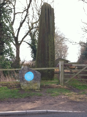
After leaving Minskip cross the River Tuut and then a brief section on an old disused railway line to reach the outskirts of Boroughbridge. Pass three menhirs known as the Devil's Arrows, one is on the right of the road after the roundabout and the two others stand in the field on the left. These are believed to have been erected in the Bronze Age and stand 22 feet 96.7m) tall. Boroughbridge is an ideal place for overnight accommodation. |
1 - With the public house behind you turn right signed High Street to the main village of Whixley. Turn left on Church Street which becomes West Lane to pass a Minotaur on the right, it won’t bite! Take the next left, signed 'Private Road no access', to pass High Farm on the right.
2 - After passing the second house, where the path turns right, continue ahead through the hedge and straight on between the fields to a track at the end. Turn right and before the wood turn left on the footpath to reach a track. Bear right to the T-junction and turn left, direction A168 2/3 mile to pass houses on the left.
3 - At the tarmac lane turn right to the T-junction, then turn right onto the Bridleway / old road to reach the new A168 road. Turn right to pass the Farm shop and then after passing Rougham Farm on the same side, turn left across the A1/M1 road, direction Arkendale.
4 - In Arkendale continue pass the church on the left and at the public house turn right, signed Westfield Lane. As the road turns left, bear right onto the Bridleway and where it turns right keep ahead with a hedge on the left. The path becomes narrow passing between fields with hedges either side. This may be boggy due to horse traffic. Pass through a wooden gate and at the end of the hedge / trees on the left turn left to the fence corner and the farm ahead
5 - At the fence corner turn right and diagonally across the field, over a stream to the far right corner, and a gate. Pass through the gate and continue ahead to pass High View house on the right and then bear left onto the tarmac lane which becomes Arkendale Lane to reach the A6055 road. Ignore path / track right and left.
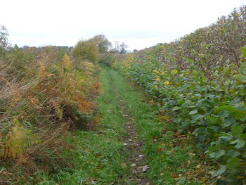
6 - At the A6055 turn right to Minskip village and take the first road left, direction Slaley. After passing the Minskip sign on the right turn right onto the Bridleway to pass Thorndikes on the left. Where the Bridleway turns left keep ahead to cross the stile to the right of the gate. Continue ahead through the fields keeping to the right to then cross a bridge over the River Tutt. Continue ahead across the field towards the telegraph pole to reach the old railway line.
7 - Turn right and follow the railway line to the end and then continue ahead to pass round large industrial buildings, passing a nature reserve on the left. At the road turn right and keep ahead at the roundabout. The first of the Menhirs is on the right hand side. After maybe a brief stop to read about the Devils Arrow's, turn left onto Roecliffe Lane passing the other two menhirs on the left in the field. Turn right at Valution Lane to reach Boroughbridge and the end of the stage.
